Track 1: GIS
Geographic information system (GIS) is a system designed to capture, store, manipulate, analyse, manage, and present all types of spatial or geographical data. The acronym GIS is sometimes used for geographical information science or geospatial information studies to refer to the academic discipline or career of working with geographic information systems and is a large domain within the broader academic discipline of Geo informatics. GIS is a broad term that can refer to a number of different technologies, processes, and methods. It is attached to many operations and has many applications related to engineering, planning, management, transport/logistics, insurance, telecommunications, and business.
Relevant: | GIS Conferences | Remote Sensing Conferences |
3rd Global Geologists Annual Meeting, July 11-12, 2016 Brisbane, Australia; 2nd International Conference on Geology, April 21-22, 2016 Dubai, UAE; 5th International Conference on Earth Science and Climate Change Conference, July 25-27, 2016 Bangkok, Thailand; International Conference on Coastal Zones, May 16-18, 2016 Osaka, Japan; Global Summit on Geosciences, October 06-07, 2016 Miami; MAPPS and NSPS National (USA) Surveying and Mapping Conference, March 14-18, 2016 Arlington, Virginia USA; ICRS 2016: XIV International Conference on Remote Sensing, March 15-16, 2016 Dubai, U.A.E; 3rd Latin American Remote Sensing Week, March 29 - April 01, 2016 Santiago de Chile, Chile; International Conference on Geographic Information Systems Theory, Applications and Management (GISTAM 2016)April 26-27, 2016 Rome, Italy; EnerGIS 2016, May 16-17, 2016 Canonsburg, Pennsylvania USA.
American Society for Photogrammetry & Remote Sensing , Cartography and geographic information society (CAGIS), National centre for geographic information and analysis (NCGIA), ESRI conservation program, National centre for geographic information and analysis (NCGIA)
Track 2: Remote Sensing
Remote sensing is the process where the Remote sensors collect data by detecting the energy that is reflected from earth. These sensors can be on satellites or mounted on aircrafts. The electromagnetic radiation is normally used as an information carrier in remote sensing.. Remote sensors gather information by measuring the electromagnetic radiation that is reflected, emitted and absorbed by objects in various spectral regions, from gamma-rays to radio waves. To measure this radiation, both active and passive remote sensors are used. Passive remote sensors record natural sensors that is reflected or emitted from the earth surface. The most common source of detection is sunlight. Active sensors use internal stimuli to collect data about earth.
Remote sensing methods are used to gain a better understanding of the earth and its functions. A Global Earth Observation System of Systems (GEOSS) is being developed to connect earth observation systems around the world. A comprehensive and coordinated system of earth observations could lead to better management of environmental data and could fulfil numerous societal benefits.
Relevant: | GIS Conferences | Remote Sensing Conferences |
3rd Global Geologists Annual Meeting, July 11-12, 2016 Brisbane, Australia; 2nd International Conference on Geology, April 21-22, 2016 Dubai, UAE; 5th International Conference on Earth Science and Climate Change Conference, July 25-27, 2016 Bangkok, Thailand; International Conference on Coastal Zones, May 16-18, 2016 Osaka, Japan; Global Summit on Geosciences, October 06-07, 2016 Miami, USA; Esri European Petroleum GIS Conference, November 5-6, 2015 London, United Kingdom; MAPPS and NSPS National (USA) Surveying and Mapping Conference, March 14-18, 2016 Arlington, Virginia USA; ICRS 2016: XIV International Conference on Remote Sensing, March 15-16, 2016 Dubai, U.A.E; 3rd Latin American Remote Sensing Week, March 29 - April 01, 2016 Santiago de Chile, Chile
American Society for Photogrammetry & Remote Sensing , Cartography and geographic information society (CAGIS), National centre for geographic information and analysis (NCGIA), ESRI conservation program, National centre for geographic information and analysis (NCGIA)
Track 3: Geodynamics
Geodynamics is the study of motion and change on Earth. It provides the quantitative foundation for the theory of Plate Tectonics, Volcanism, the chemistry of lava and volcanic rocks, gravity and geomagnetic anomalies as well as seismic investigations into the structure of the mantle. The basic organizing paradigm for our understanding of the Solid Earth. Geodynamics specializes in high-end Geographic Information Systems, offering a broad spectrum of GIS services from simple data conversion to complex hydrographical data processing, data modelling and analysis.
Geodynamics is a broad field which combines observations from many different types of geological study into a broad picture of the dynamics of Earth. Close to the surface of the Earth, data includes field observations, geodesy, radiometric dating, petrology, mineralogy, drilling boreholes and remote sensing techniques.
Relevant: | GIS Conferences | Remote Sensing Conferences |
3rd Global Geologists Annual Meeting, July 11-12, 2016 Brisbane, Australia; 2nd International Conference on Geology, April 21-22, 2016 Dubai, UAE; 5th International Conference on Earth Science and Climate Change Conference, July 25-27, 2016 Bangkok, Thailand; International Conference on Coastal Zones, May 16-18, 2016 Osaka, Japan; Global Summit on Geosciences, October 06-07, 2016 Miami; Esri Ocean GIS Forum, November 4-6, 2015 Redlands, CA; Tectonic and geodynamic evolution of Eastern Iran November 02–06 , 2015 Tehran and Birjand, Iran; 2016 Conference on Big Data from Space (BiDS'16) March 15-17, 2016 Santa Cruz de Tenerife, Spain; International Conference on Geographic Information Systems Theory, Applications and Management (GISTAM 2016)April 26-27, 2016 Rome, Italy; EnerGIS 2016, May 16-17, 2016 Canonsburg, Pennsylvania USA.
American Society for Photogrammetry & Remote Sensing , Cartography and geographic information society (CAGIS), National centre for geographic information and analysis (NCGIA), ESRI conservation program, National centre for geographic information and analysis (NCGIA)
Track 4: GIS Software
Geographic Information System software is designed to store, retrieve, manage, display, and analyse all types of geographical and spatial data. GIS software lets you produce maps and other graphic displays of geographic information for analysis and presentation. With these capabilities a GIS is a valuable tool to visualize spatial data or to build decision support systems for use in multiple organizations. GIS software systems are often specialized to fit certain types of decision making. That is, they are customized to meet needs specific to demographic forecasting, transportation planning, environmental resource analysis, urban planning, and so on. The great appeal of GIS stems from their ability to integrate great quantities of information about the environment and to provide a powerful repertoire of analytical tools to explore data.
Relevant: | GIS Conferences | Remote Sensing Conferences |
3rd Global Geologists Annual Meeting, July 11-12, 2016 Brisbane, Australia; 2nd International Conference on Geology, April 21-22, 2016 Dubai, UAE; 5th International Conference on Earth Science and Climate Change Conference, July 25-27, 2016 Bangkok, Thailand; International Conference on Coastal Zones, May 16-18, 2016 Osaka, Japan; Global Summit on Geosciences, October 06-07, 2016 Miami; MAPPS and NSPS National (USA) Surveying and Mapping Conference, March 14-18, 2016 Arlington, Virginia USA; ICRS 2016: XIV International Conference on Remote Sensing, March 15-16, 2016 Dubai, U.A.E; 3rd Latin American Remote Sensing Week, March 29 - April 01, 2016 Santiago de Chile, Chile; International Conference on Geographic Information Systems Theory, Applications and Management (GISTAM 2016)April 26-27, 2016 Rome, Italy; EnerGIS 2016, May 16-17, 2016 Canonsburg, Pennsylvania USA.
American Society for Photogrammetry & Remote Sensing , Cartography and geographic information society (CAGIS), National centre for geographic information and analysis (NCGIA), ESRI conservation program, National centre for geographic information and analysis (NCGIA)
Track 5: Digital Earth
Digital Earth concerns the integrated use of digital technologies to monitor, map, model, and manage our planet’s environment and it is the global invitation for the collaborative effort between the Earth science, Space science and Informative science. The Digital Earth vision was first proposed by Al Gore in 1998, and has evolved to keep pace with rapid developments in earth-sensing, cloud computing, and Big Data.
Geographic Information Systems are computer software and hardware systems that enable users to capture, store, analyse and manage spatially referenced data. GIS have transformed the way spatial geographic data, relationships and patterns in the world are able to be interactively queried, processed, analysed, mapped, modelled, visualised, and displayed for an increasingly large range of users, for a multitude of purposes.
Relevant: | GIS Conferences | Remote Sensing Conferences |
3rd Global Geologists Annual Meeting, July 11-12, 2016 Brisbane, Australia; 2nd International Conference on Geology, April 21-22, 2016 Dubai, UAE; 5th International Conference on Earth Science and Climate Change Conference, July 25-27, 2016 Bangkok, Thailand; International Conference on Coastal Zones, May 16-18, 2016 Osaka, Japan; Global Summit on Geosciences, October 06-07, 2016 Miami; Esri Ocean GIS Forum, November 4-6, 2015 Redlands, CA; Tectonic and geodynamic evolution of Eastern Iran November 02–06 , 2015 Tehran and Birjand, Iran; 2016 Conference on Big Data from Space (BiDS'16) March 15-17, 2016 Santa Cruz de Tenerife, Spain; International Conference on Geographic Information Systems Theory, Applications and Management (GISTAM 2016)April 26-27, 2016 Rome, Italy; EnerGIS 2016, May 16-17, 2016 Canonsburg, Pennsylvania USA.
American Society for Photogrammetry & Remote Sensing , Cartography and geographic information society (CAGIS), National centre for geographic information and analysis (NCGIA), ESRI conservation program, National centre for geographic information and analysis (NCGIA)
Track 6: GIS IN MAPPING
Geographic Information Systems that offers a radically different way in which we produce and use the maps required to manage our communities and industries. A geographic information system (GIS) is a computer system for capturing, storing, checking, and displaying data related to positions on Earth’s surface. GIS can show many different kinds of data on one map. Once the desired data has been entered into a GIS system they can produce a wide variety of individual maps, depending on which data layers are included. GIS maps can also use to show data about density and number. GIS` technology combines database, mapping and statistical methods to integrate georeferenced data into visual displays where the relationships, patterns and trends in the data can be more easily identified.
Relevant: | GIS Conferences | Remote Sensing Conferences |
3rd Global Geologists Annual Meeting, July 11-12, 2016 Brisbane, Australia; 2nd International Conference on Geology, April 21-22, 2016 Dubai, UAE; 5th International Conference on Earth Science and Climate Change Conference, July 25-27, 2016 Bangkok, Thailand; International Conference on Coastal Zones, May 16-18, 2016 Osaka, Japan; Global Summit on Geosciences, October 06-07, 2016 Miami; MAPPS and NSPS National (USA) Surveying and Mapping Conference, March 14-18, 2016 Arlington, Virginia USA; ICRS 2016: XIV International Conference on Remote Sensing, March 15-16, 2016 Dubai, U.A.E; 3rd Latin American Remote Sensing Week, March 29 - April 01, 2016 Santiago de Chile, Chile; 8th IGRSM International Conference and Exhibition on Remote Sensing & GIS (IGRSM 2016)April 13-14, 2016 Kuala Lumpur, Malaysia; International Conference on Geographic Information Systems Theory, Applications and Management (GISTAM 2016)April 26-27, 2016 Rome, Italy.
American Society for Photogrammetry & Remote Sensing , Cartography and geographic information society (CAGIS), National centre for geographic information and analysis (NCGIA), ESRI conservation program, National centre for geographic information and analysis (NCGIA)
Track 7: Seismology and Geodesy
Seismology is the study of earthquakes and seismic waves. Seismic waves are the waves of energy caused by the sudden breaking of rock within the earth or an explosion. They are the energy that travels through the earth and is recorded on seismographs. GIS helps to manage the impact of Earthquakes and other disasters by assessing risk and hazard locations in relation to populations, property, and natural resources, Integrating data and enabling understanding of the scope of an emergency to manage an incident and identifying staging area locations, operational branches and divisions, and other important incident management needs. Geodesy is the science of accurately measuring and understanding three fundamental properties of the earth its geometric shape, its orientation in space, and its gravity field as well as the changes of these properties with time. In relation to GIS, geodesy provides the fundamental framework for accurate positions on or near the Earth’s surface.
Relevant: | GIS Conferences | Remote Sensing Conferences |
3rd Global Geologists Annual Meeting, July 11-12, 2016 Brisbane, Australia; 2nd International Conference on Geology, April 21-22, 2016 Dubai, UAE; 5th International Conference on Earth Science and Climate Change Conference, July 25-27, 2016 Bangkok, Thailand; International Conference on Coastal Zones, May 16-18, 2016 Osaka, Japan; Global Summit on Geosciences, October 06-07, 2016 Miami; 8th IGRSM International Conference and Exhibition on Remote Sensing & GIS (IGRSM 2016)April 13-14, 2016 Kuala Lumpur, Malaysia; 8th International Conference on Advanced Geographic Information Systems, Applications, and Services (GEO Processing 2016)April 24-28, 2016 Venice, Italy; International Conference on Geographic Information Systems Theory, Applications and Management (GISTAM 2016)April 26-27, 2016 Rome, Italy; EnerGIS 2016, May 16-17, 2016 Canonsburg, Pennsylvania USA; Geospatial World Forum 2016 May 23-26, 2016 Rotterdam, The Netherlands.
American Society for Photogrammetry & Remote Sensing , Cartography and geographic information society (CAGIS), National centre for geographic information and analysis (NCGIA), ESRI conservation program, National centre for geographic information and analysis (NCGIA)
Track 8: Global Navigation Satellite System (GNSS)
GNSS is a satellite system that is used to pinpoint the geographic location of a user's receiver anywhere in the world. Global Navigation Satellite Systems (GNSS) include constellations of Earth-orbiting satellites that broadcast their locations in space and time, of networks of ground control stations, and of receivers that calculate ground positions by trilateration. GNSS are used in all forms of transportation: space stations, aviation, maritime, rail, road and mass transit. Positioning, navigation and timing play a critical role in telecommunications, land surveying, law enforcement, emergency response, precision agriculture, mining, finance, scientific research and so on. They are used to control computer networks, air traffic, power grids and more. Two GNSS systems are currently in operation: the United States' Global Positioning System (GPS) and the Russian Federation's Global Orbiting Navigation Satellite System (GLONASS), as well as the developing global and regional systems, namely Europe’s European Satellite Navigation System (GALILEO) and China’s COMPASS/BeiDou, India’s Regional Navigation Satellite System (IRNSS) and Japan’s Quasi-Zenith Satellite System (QZSS). Once all these global and regional systems become fully operational, the user will have access to positioning, navigation and timing signals from more than 100 satellites.
Relevant: | GIS Conferences | Remote Sensing Conferences |
3rd Global Geologists Annual Meeting, July 11-12, 2016 Brisbane, Australia; 2nd International Conference on Geology, April 21-22, 2016 Dubai, UAE; 5th International Conference on Earth Science and Climate Change Conference, July 25-27, 2016 Bangkok, Thailand; International Conference on Coastal Zones, May 16-18, 2016 Osaka, Japan; Global Summit on Geosciences, October 06-07, 2016 Miami; Esri European Petroleum GIS Conference, November 5-6, 2015 London, United Kingdom; MAPPS and NSPS National (USA) Surveying and Mapping Conference, March 14-18, 2016 Arlington, Virginia USA; ICRS 2016: XIV International Conference on Remote Sensing, March 15-16, 2016 Dubai, U.A.E; 3rd Latin American Remote Sensing Week, March 29 - April 01, 2016 Santiago de Chile, Chile; International Conference on Geographic Information Systems Theory, Applications and Management (GISTAM 2016)April 26-27, 2016 Rome, Italy.
American Society for Photogrammetry & Remote Sensing , Cartography and geographic information society (CAGIS), National centre for geographic information and analysis (NCGIA), ESRI conservation program, National centre for geographic information and analysis (NCGIA)
Track 9: GIS in Disaster management
Geographic Information Systems (GIS) and remote sensing (RS) are very useful and effective tools in disaster management. Various disasters like earthquakes, landslides, floods, fires, tsunamis, volcanic eruptions and cyclones are natural hazards that kill lots of people and destroy property and infrastructures every year. Landslides are the most regular geological vulnerabilities in mountain regions. Remotely sensed data can be used very efficiently to assess severity and impact of damage due to these disasters. In the disaster relief phase, GIS, grouped with global positioning system (GPS) is extremely useful in search and rescue operations in areas that have been devastated and where it is difficult to find one’s bearings. Disaster mapping is the drawing of areas that have been through excessive natural or man-made troubles to the normal environment where there is a loss of life, property and national infrastructures.
Relevant: | GIS Conferences | Remote Sensing Conferences |
3rd Global Geologists Annual Meeting, July 11-12, 2016 Brisbane, Australia; 2nd International Conference on Geology, April 21-22, 2016 Dubai, UAE; 5th International Conference on Earth Science and Climate Change Conference, July 25-27, 2016 Bangkok, Thailand; International Conference on Coastal Zones, May 16-18, 2016 Osaka, Japan; Global Summit on Geosciences, October 06-07, 2016 Miami; International Conference on Geographic Information Systems Theory, Applications and Management (GISTAM 2016)April 26-27, 2016 Rome, Italy; EnerGIS 2016, May 16-17, 2016 Canonsburg, Pennsylvania USA; Geospatial World Forum 2016 May 23-26, 2016 Rotterdam, The Netherlands; 6th International Conference on Cartography & GIS, June 13-17, 2016 Albena, Bulgaria; 19th AGILE Conference on Geographic Information Science, June 14-17, 2016 Helsinki, Finland.
American Society for Photogrammetry & Remote Sensing , Cartography and geographic information society (CAGIS), National centre for geographic information and analysis (NCGIA), ESRI conservation program, National centre for geographic information and analysis (NCGIA)
Track 10: GIS Market
The most important component of Geographic Information Systems is its requirement for spatial data. Spatial data is any kind of information that has been collected, compiled, or processed with a spatial component, that is, a tie to a geographic location on the surface of the Earth. It so happens that this is a large segment of the spatial industry, often consuming an appreciable portion of dollars assigned to GIS implementation projects. Spatial data management is increasingly a consideration in any information management system (IMS) due to the fact that large amounts of data are being collected with spatial components. Businesses and government organizations are realizing that a traditional IMS does not allow an organization to leverage the value of spatial information inherent in their data. This has led to the development of software tools as extensions to commercial Data Management Systems (DMS) that allow for better storage, manipulation, and query of spatial data.
Relevant: | GIS Conferences | Remote Sensing Conferences |
3rd Global Geologists Annual Meeting, July 11-12, 2016 Brisbane, Australia; 2nd International Conference on Geology, April 21-22, 2016 Dubai, UAE; 5th International Conference on Earth Science and Climate Change Conference, July 25-27, 2016 Bangkok, Thailand; International Conference on Coastal Zones, May 16-18, 2016 Osaka, Japan; Global Summit on Geosciences, October 06-07, 2016 Miami; Esri European Petroleum GIS Conference, November 5-6, 2015 London, United Kingdom; MAPPS and NSPS National (USA) Surveying and Mapping Conference, March 14-18, 2016 Arlington, Virginia USA; ICRS 2016: XIV International Conference on Remote Sensing, March 15-16, 2016 Dubai, U.A.E; 3rd Latin American Remote Sensing Week, March 29 - April 01, 2016 Santiago de Chile, Chile; 8th IGRSM International Conference and Exhibition on Remote Sensing & GIS (IGRSM 2016)April 13-14, 2016 Kuala Lumpur, Malaysia.
American Society for Photogrammetry & Remote Sensing , Cartography and geographic information society (CAGIS), National centre for geographic information and analysis (NCGIA), ESRI conservation program, National centre for geographic information and analysis (NCGIA)
Summary of GIS and Remote Sensing Conference:
GIS and Remote Sensing conference aims to aggregate researchers, academicians and scientists from the Geographic Information System and Remote Sensing community and to create a platform for robust exchange of information on technological advances, new scientific achievements and the effectiveness of various regulatory programs towards GIS and remote sensing. It provides a premier technical forum for reporting and learning about the latest research and development, as well as for launching new applications and technologies. This shows how a GIS in combination with geological data sets can be used to solve specific geological problems. The training on digital image processing focuses on the usage of field and laboratory spectral data to gain a better understanding of Remote Sensing products. Advanced image processing techniques are introduced and applied using Landsat. We welcome all the contributors and participants to join GIS-2016 and it will be a perfect platform to share your research and knowledge with the professionals from all over the world.
Importance and scope:
The field of remote sensing and GIS has become exciting and enchanting with rapidly expanding opportunities. Geographical information system (GIS) is designed to capture, store and manage all types of geographical data. Remote sensing is the accession of information about the object without any physical contact. There are wide range of applications in the field of GIS and remote sensing. Remote sensing also replaces expensive and slow data collection on the ground, ensuring in the process that areas or objects are not disturbed.
GIS and Remote Sensing conference will place a platform where worldwide researchers, academicians and scientists from the Geographic Information System and Remote Sensing community will aggregate to create a platform for robust exchange of information on technological advances, new scientific achievements and the effectiveness of various regulatory programs towards GIS and Remote sensing. It provides a premier technical forum for reporting and learning about the latest research and development, as well as for launching new applications and technologies. It will promote science and technology of the relevant fields of GIS and Remote Sensing.
Why New Orleans USA???
New Orleans is a major United States port and the largest city and metropolitan area in the state of Louisiana. The city is named after the Duke of Orleans, who reigned as Regent for Louis XV from 1715 to 1723, as it was established by French colonists and strongly influenced by their European culture. It is well known for its distinct French and Spanish Creole architecture, as well as its cross-cultural and multilingual heritage. New Orleans is also famous for its cuisine, music, and its annual celebrations and festivals, most notably Mardi Gras, dating to French colonial times. The city is often referred to as the “most unique” in the United States and it is located in south-eastern Louisiana, straddling the Mississippi River. New Orleans’ colonial history of French and Spanish settlement has resulted in a strong Catholic tradition. Catholic missions administered to slaves and free people of color, establishing schools for them. Tourism is another staple of the city’s economy. Perhaps more visible than any other sector, New Orleans’ tourist and convention industry is a $5.5 billion juggernaut that accounts for 40 percent of New Orleans’ tax revenues. In 2004, the hospitality industry employed 85,000 people, making it New Orleans’ top economic sector as measured by employment totals. The city also hosts the World Cultural Economic Forum (WCEF). The forum, held annually at the New Orleans Morial Convention Center, is directed toward promoting cultural and economic development opportunities through the strategic convening of cultural ambassadors and leaders from round the world.
Conference Highlights:
GIS
Remote Sensing
Geo dynamics
GIS Software
Digital Earth
GIS In Mapping
Seismology and Geodesy
Global Navigation Satellite System
GIS in Disaster Management
GIS Market
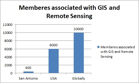
Members Associated with GIS and Remote Sensing Research:
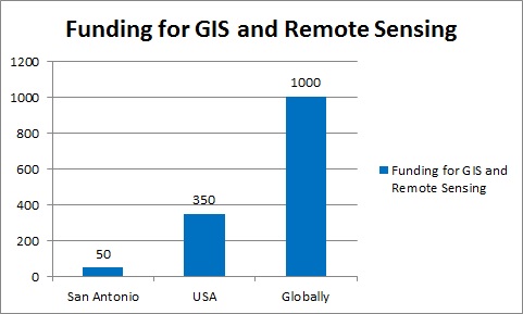
For the field of GIS and Remote Sensing people are working along with many universities, individual Institutions, associations and societies. Around 450 members in San Antonio, 6000 in USA, More than 8000 physicians, academicians and researchers.
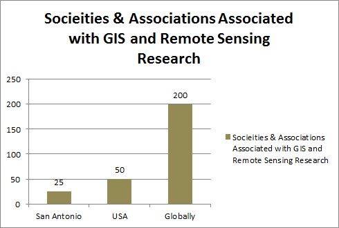
Societies & Associations Associated with GIS and Remote Sensing Research:
American Society for Photogrammetry & Remote Sensing
Cartography and geographic information society (CAGIS)
Centre for advanced spatial technologies (CAST)
Centre for spatially integrated social science (CSISS)
Earth sciences & map library, university of California Berkeley library
ESRI conservation program
Federal geographic data committee (FGDC)
Geo community
Geodata alliance
National centre for geographic information and analysis (NCGIA)
National geospatial-intelligence agency (NGA)
Open geospatial consortium (OGC)
Society for conservation GIS (SCGIC)
GIS speciality group
Association for Geographic Information
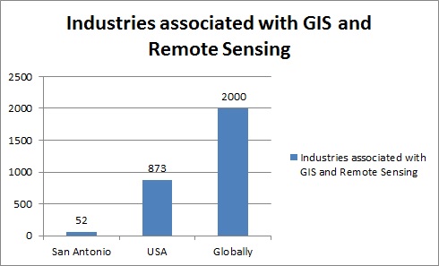
Industries Associated with GIS and Remote Sensing Research:
3D Laser Mapping
Aarvee associates
Aero-Metric, inc.
AML Solutions Group
Angus Geosolutions Inc. (AGSI)
Avineon India Private Limited
BroadMap
CARIS
Cinco GIS
Complete Spatial Solutions
Datamap
Spatial (Formerly Laser Scan)
http://ecat.giscafe.com/corplist.php
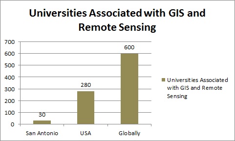
Universities Associated with GIS and Remote Sensing Research in USA:
Acadia University
Alabama A&M University
American Sentinel University
Appalachian State University
Arizona State University
California State Polytechnic University
Central Connecticut State University
Central Washington University
Claremont Graduate University
Delta State University
East Carolina University
George Mason University
Humboldt State University
Indiana University at Pennsylvania
Louisiana Technical University
North Carolina State Universit
San Francisco State University
University of Akron
University of Southern California
http://www.urisa.org/careers/colleges-and-universities/
Target Audience:
Academicians, Research scientists, Students, young researchers, professors from different universities containing GIS and Remote Sensing studies, eminent persons from different associations and societies, directors, CEO’s from different companies.
-
Academia 40%
-
Industry 30%
-
Associations 20%
-
Government 10%
I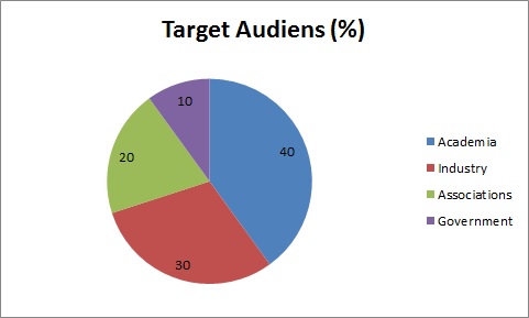
Total business of GIS and Remote Sensing market Japan, South Korea, Canada, US, UK, Germany, India, Brazil for the globla geo-services market to be between $ 150 billion and $ 270 billion, chinese government is $ 31 billion.
Funding for GIS and Remote Sensing:
References: 1) http://ecat.giscafe.com/corplist.php
2) http://www.urisa.org/careers/colleges-and-universities/
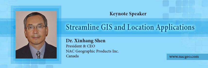

 Xinhang Shen
 J. Sanchez del RÃo Saez
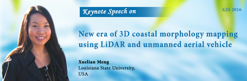
 Xuelian Meng
 Sherif Ishak
 Hai Guo
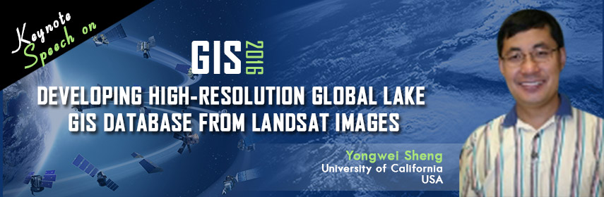
 Yongwei Sheng